

Avetics Global is DJI Authorised Enterprise Dealer in Singapore and has experienced staff who have actual operational experience and can help recommend the most suitable drone for your requirements.
DJI Phantom 4 RTK


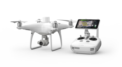
DJI Phantom 4 RTK
Phantom 4 RTK - Next Generation Mapping
Upgrade your next mapping mission with the Phantom 4 RTK – the most compact and accurate low altitude mapping solution.
Stock available in Singapore. Contact us now!
Next-Generation Mapping
A new RTK module provid real-time, centimeter-level positioning data for improved absolute accuracy on image metadata.
Installed beneath the RTK receiver is a GNSS module that helps to maintain flight stability in signal-poor regions such as dense cities.
Combining both modules, the Phantom 4 RTK can optimize flight safety while ensuring the most precise data is captured for complex surveying, mapping and inspection workflows.
Features
0.5cm+1ppm
RTK Vertical Positioning Accuracy1cm+1ppm
RTK Horizontal Positioning Accuracy30 min flight time
4k video resolution at 60fps
20MP, 1” CMOS Sensor for superior photo-taking
30m sensor range
5 direction obstacle sensing


Built for Surveyors
Offering a range of control schemes and complementary technologies,
the DJI Phantom 4 RTK is developed to provide survey-grade results with greater efficiency than ever before.
With a built-in flight planning app (GS RTK) and an easy method to collect RTK data (RTK Network or D-RTK 2 Mobile Station), pilots have a full solution for any surveying, mapping or inspection workflow – right out of the box.
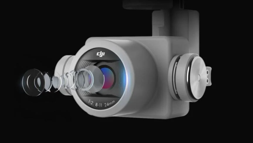
Precise Imaging System
Capture the best image data with a 1-inch, 20-megapixel CMOS sensor.
Mechanical shutter makes mapping missions or regular data capture seamless as the Phantom 4 RTK can move while taking pictures without the risk of rolling shutter blur.
Due to the high resolution, the Phantom 4 RTK can achieve a ground sample distance (GSD) of 2.74 cm at 100 meters flight altitude.

Centimeter-Level Positioning System
A new RTK module is integrated directly into the Phantom 4 RTK, providing real-time, centimeter-level positioning data for improved absolute accuracy on image metadata. In addition to optimized flight safety and precise data collection.
The Phantom 4 RTK stores satellite observation data to be used for Post Processed Kinematics (PPK), which can be conducted using DJI Cloud PPK Service*.
Fit the Phantom 4 RTK to any workflow, with the ability to connect this positioning system to the D-RTK 2 High Precision GNSS Mobile Station, or NTRIP (Network Transport of RTCM via Internet Protocol) using a 4G dongle or WiFi hotspot.

Gather Accurate Data with TimeSync
To take full advantage of the Phantom 4 RTK’s positioning modules, the new TimeSync system was created to continually align the flight controller, camera and RTK module.
Additionally, TimeSync ensures each photo uses the most accurate metadata and fixes the positioning data to the optical center of the lens – optimizing the results from photogrammetric methods and letting the image achieve centimeter-level positioning data.

Seamless Compatibility with D-RTK 2 Mobile Station
Support your Phantom 4 RTK missions with the D-RTK 2 Mobile Station – providing real-time differential data to the drone and forming an accurate surveying solution, or acquire accurate location coordinates when used as an RTK rover. The Mobile Station’s rugged design and OcuSync transmission system ensures you can gain centimeter-level accurate data with your Phantom 4 RTK in any condition.


